
Table of Contents
If you’re looking for a delightful ridge hike, head for the Jumpingpound Summit trail off Powderface Trail – the dirt access road in Alberta’s Kananaskis Country. Once you reach treeline, you’ll be treated to lovely views of the Fisher Range peaks, while the massive Moose Mountain dominates the scene to the east from the Jumpingpound summit. In summer enjoy the wildflowers.
Most people enjoy the northern portion of the Jumpingpound Summit trail as an out and back hike. If you have friends who are keen to join you – and have a car, then you could hike the entire ridge with a finish at the Canyon Creek parking lot.
The trail is often doable until the road closes on December 1st. In the spring according to Gillian Daffern, “snow can be waist deep on the lee slope section of the north ridge“, so either be prepared to scrabble over the boulder field – or simply wait and hike it starting later in June.
This post includes some affiliate links. If you make a qualifying purchase through one of these links, I will receive a small percentage of the sale at no extra cost to you. I very much appreciate your support.
 Nice views to the west once you get out of the trees on the Jumpingpound Summit trail
Where is the Jumpingpound Summit trailhead?
From Calgary drive west on the Trans-Canada Highway. Get off at Exit 143 – the Sibbald Creek Trail. Go south and then west on Highway 68/Sibbald Creek Trail for approximately 23 km. It is a dirt road in places. Shortly after passing the Sibbald Lake Recreation Area turn left or south onto Powderface Trail – also a dirt road that is closed from December 1 – May 15 every year. Follow it for 10.2 km to the Lusk Pass parking area on the right (or west). The Jumpingpound Summit trail starts across the road – and is signed.
Your other option is to take Highway 66 to where it meets the Powderface Trail at the intersection to the Little Elbow Provincial Recreation Area. Drive north for 18 km on the Powderface Trail to the Lusk Pass parking area.
Expect to have either a dusty or a muddy car at the end of the drive on the Powderface Trail.
 Parking at the Lusk Pass trailhead across the road from the start of the trail to Jumpingpound Summit
Do you need a permit?
You are in Kananaskis Country so you will need a Kananaskis Conservation Pass. They are easy to purchase online but you’ll need a license plate number. It’s $15 for a day or $90 for a yearly pass.
 Part of the trail Jumpingpound Ridge trail is also part of the Trans Canada Trail
Jumpingpound Trail location
Jumpingpound Summit Trail summary
Distance: 14.6 km as an out and back hike OR 13.8 km one way if you have two vehicles and one is parked at the Canyon Creek parking lot on the Powderface Trail.
Elevation gain: 701 m (2,300 feet)
Difficulty: Moderate because of elevation gain and distance.
Time needed: Allow 5 – 6 hours depending on your pace and what time of year you hike. In summer you may want to enjoy an extended lunch on top with a marvelous view of Moose Mountain.
Dogs: Permitted on a leash.
Wildlife: It’s bear country, so carry easy to access bear spray. I recommend a bear spray holster.
Water: The only water is in the creek you cross at the start and end of the hike. On a hot summer’s day, you could fill a water bottle like this one with a microfilter for the drive home.
Don’t forget: Pack the 10 hiking essentials. It can be very blowy on top so be sure to have extra layers.
Please: Practice the seven Leave No Trace principles. There are no garbage cans at the trailhead, so pack out everything you packed in.
 Me on the summit of the Jumpingpound Trail
Jumpingpound Summit trail description
From the Lusk Pass parking lot cross Powderface Trail (the highway) onto the start of the signed Jumpingpound Trail. In very short order cross a bridge over Jumpingpound Creek and then start hiking a series of long switchbacks up through the forest.
The trail moderates briefly and then climbs more steeply to reach treeline and the southern end of the Cox Hill Ridge trail. You’ve hiked 4.1 km to this point.
 Immediately cross this bridge
  Walk up through the forest on the wide Jumpingpound Summit trail
  Views part way up to the junction with the Cox Hill trail
  Peek a boo view of Cox Hill part way up
  The junction of the Jumpingpound Summit trail with the Cox Hill Trail
The trail to the Jumpingpound summit
Turn right to stay on the Jumpingpound Summit trail. It’s 3.2 km one way to reach the summit from the intersection with the Cox Hill Trail. The ridge undulates all the way to the summit, but you can count on some lovely flat hiking. The wind blasted us at times when we hiked this section of the trail in mid-October. I usually warm up quickly, but on this day I never took off my down coat.
We passed a large cairn – and you could climb to the summit from here and shave off a bit of distance. Instead, we continued to the next junction. From there, heading uphill is the clear route to the Jumpingpound summit, just a short 5–7 minute hike over 320 metres.
After snapping a few photos on the summit, it was a dash to descend and escape the wind. On a calm day, though, this would be an ideal place to linger – enjoying lunch and soaking in the sweeping views.
 Microspikes came in handy (at least for me) in mid-October when we hiked the Jumpingpound Summit trail
  Mostly gentle easy hiking on the way to the Jumpingpound Summit
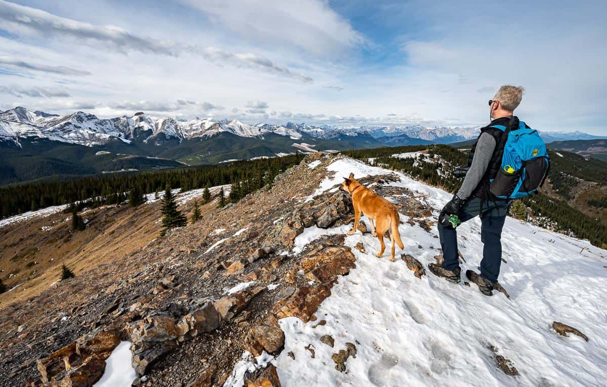
  The Jumpingpound Summit comes into view – with Moose Mountain in the distant background
  We ignored this cairn and continued following footsteps in the snow to the next intersection
  It’s easy to bag the summit on the Jumpingpound Trail
  A couple going the other way on Jumpingpound Ridge from the intersection with the trail to the summit
  John and I on the summit of Jumpingpound Trail in mid-October on our anniversary
  Summit views from Jumpingpound Summit Trail
Descent from the summit
It’s a straightforward, fast hike back to the parking lot from the Jumpingpound Summit. The clouds overhead – a chinook arch if I’m not mistaken – though I didn’t expect them in this area, are a predictor of warm, dry winds.
 Heading down from the Jumpingpound Ridge summit
  Following our snowy tracks back to the parking lot
  Crazy clouds overhead on the descent from Jumpingpound Summit
  The dog is keen to get back to the car
Add-ons to the Jumpingpound Summit hike
If you had two cars you could leave one at the Dawson Provincial Recreation Area (here on Google maps) and another at the Lusk Pass trailhead. Hike up Cox Hill on the Cox Hill Trail – part of the Trans-Canada Trail. Follow it for 3.0 km to meet the Jumpingpound Ridge Trail.
Then do and out and back to the Jumpingpound Ridge Summit and descend to the Lusk Pass trailhead where you’ve left the other car. You’ll have a full day of hiking – covering 19.8 km in total.
Yet another option, again with two cars is to hike up Cox Hill, and then follow the length of the Jumpingpound Trail, to finish at the Canyon Creek parking lot. That would run about 16.5 km but would involve more driving.
 The Cox Hill Trail looking southwest
What to take on the hike
If you’d like to learn more about the wildflowers you see on the Jumpingpound Summit trail, check out Alberta Trees and Wildflower Guide. From mid-July for about a month you can expect to see wildflowers along the ridge.
At lunch time a bum cushion is great for comfort – and especially great on wet or cold days.
Once the cold weather hits, pack some hand warmers like these ones.
Pack microspikes and hiking poles if you’re doing the hike once there is snow on the ground.
Where to stay nearby
There is reservable camping at Sibbald Lake Provincial Campground off Sibbald Creek Trail. There are 134 unserviced sites with availability from mid May until the second week of October.
Check out my Complete Guide to Camping in Kananaskis for all the camping options.
If you’re into glamping, you might like Skyridge Glamping just off Highway 40 – though it’s on the pricey side.
The Kananaskis Wilderness Hostel is an affordable option in a great location.
Nearby Sundance by Basecamp offers tipis, cabins, family glamping tents and more.
More hikes in the general area you’ll want to try
Click on the photo to bookmark to your Pinterest boards.
